Orderville, Utah Demonstration of Ultra-High Resolution Remote Sensing
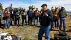
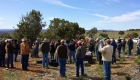
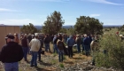
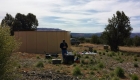
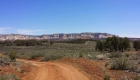
On Wednesday, April 8th, UtahView had the opportunity to present the uses of ultra-high resolution remote sensing to the 37th Annual Range Livestock Workshop and Tour attendees near Orderville and Mount Carmel Junction in southern Utah. The workshop, a joint effort by Utah State University Extension and Arizona Cooperative Extension, presents a series of critical and pertinent topics management and environmental topics to land owners and land managers as well as local range tours.
The 37th workshop presented topics that included information on the impacts of sulfur in stock water and forage, best practices for private land owners to work with agencies, planning grazing systems, and a host of other topics. Included in those topics was the use of high-resolution cameras on remote vehicles to capture range-related vegetation data. News reports and hints of use of unmanned vehicles has spurred a good deal of interest, especially among private land owners – both with concerns regarding privacy, but also a significant interest in the use of such tools to improve how they operate and manage their property.
UtahView Principal Investigator Dr. Doug Ramsey and State View Coordinator Chris McGinty were invited by Utah State University Extension to explain the use of unmanned vehicles, along with some of the privacy and regulatory concerns surrounding the use of such tools. Additionally, an in-depth discussion was held regarding the use of remote sensing, in general, and how remote sensing and varying scales, ranging from centimeters to hundreds of meters (or ultra-high resolution data collected via unmanned vehicles all the way to data collected on sensor such as Landsat and MODIS) are useful in rangeland management and applications.
More than 70 local ranchers, land managers, agency personnel, and university extension agents attended the discussion.


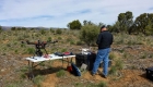


NOTE: No UtahVeiw funding is used in the purchase of unmanned vehicles or related equipment. Funds are strictly for educational purposes regarding the use of remotely sensed imagery.
UtahView at URSA – Cedar City
The Utah Rural School Association (URSA) hosted the URSA Summer Workshop for K-12 teachers in Utah on July 6 – 10, 2015 at the Southern Utah University in Cedar City, Utah. The Utah Geographic Information Council (UGIC) and UtahView spent two days teaching teachers the basics of geographic information systems (GIS), global positioning systems (GPS), Esri StoryMaps, and Google Tours.
You can download the Garmin GPS Exercise which starts with the basics of using Garmin GPSMAP 64 units (also good for 60Cx and 62 models) here.
Dr. Phoebe McNeally, Director of the University of Utah DIGIT Lab, and Chris McGinty, Associate Director of the Utah State University Remote Sensing/GIS Laboratory, provided four hours of instruction, plus a short sUAS flight demonstration to the teachers.

