On 3 November 2015, Beaver County USU Extension Agent and Director, Dr. Mark Nelson, invited the Remote Sensing/GIS Laboratory and UtahView to present a short lecture on the use of ultra-high resolution remote sensing for rangelands as part of the Beaver River Watershed Tour & Pesticide Training.
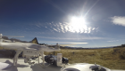
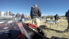
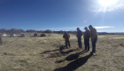
Remote Sensing/GIS Laboratory Director and UtahView Principal Investigator, Dr. Doug Ramsey, State View Coordinator Chris McGinty, and graduate student Tommy Thompson were invited by Utah State University Extension to explain the use of unmanned vehicles, along with some of the privacy and regulatory concerns surrounding the use of such tools. Additionally, an in-depth discussion was held regarding the use of remote sensing, in general, and how remote sensing and varying scales, ranging from centimeters to hundreds of meters (or ultra-high resolution data collected via unmanned vehicles all the way to data collected on sensor such as Landsat and MODIS) are useful in rangeland management and applications.
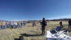
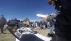
More than 70 local ranchers, land managers, agency personnel, and university extension agents attended the windy and cold discussion that was held just north of Beaver, Utah. There were many excellent questions as well as queries regarding laws, potential uses, and costs associated with unmanned vehicles.